
Bus route 213 in Leeds runs between “Dewsbury Bus Station” and “Morley Town Hall”. The two directions are not quite the same: 2 stops are served in one direction only, which is worth knowing before you travel.
Where bus 213 goes
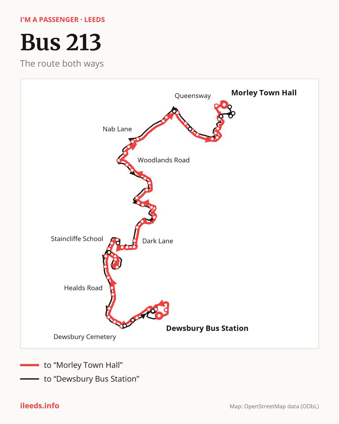
Towards “Morley Town Hall”: 56 stops. After “Dewsbury Bus Station”, the bus calls at “Longcauseway”, “Wellington Road”, “Wormald Street”, “St Matthew Road”, “Park Parade”, “Dewsbury Cemetery”, “Crow Nest Park”, “Dewsbury Moor Crematorium”, “Staincliffe Road”, “Oxford Road”. Then “School Lane”, “Healds Road”, “Staincliffe View”, “Staincliffe Park”, “Chapel Fold”, “Dewsbury & District Hospital”, “Cullingworth Street”, “Staincliffe School”, “Bunkers Lane”, “Woodside Crescent”. Then “Manor Way Parade”, “Lime Tree Avenue”, “Holly Grove”, “Dark Lane”, “Clerk Green Junction”, “Mayman Close”, “Batley Bus Station”, “Chinewood Avenue”, “County Close”, “Wyvern Close”. Then “Chinewood Avenue Top”, “Batley Grammar School”, “Hollybank Avenue”, “Old Hall Road”, “Nethercroft”, “Woodlands Road”, “Lark Hill”, “Windmill School”, “Batley Girls High School”, “Arundel Close”. Then “Windsor Road”, “Nab Lane”, “Hill Top Farm”, “M62 Motorway Bridge”, “Cliffe View”, “Parkland Avenue”, “St Andrews Avenue”, “Scotchman Lane”, “Morley ASDA”, “High Street”. Before “Morley Town Hall”: “Harlington Road”, “Elvaston Road”, “Chartists Way”, “Queensway”.
On the way back, from “Morley Town Hall” to “Dewsbury Bus Station”: 58 stops. Only in this direction does it call at, among others, “Commercial Street”, “Abbey House”, “New Pavillion”, “Weavers Close”, “St Andrew’s Avenue” and “Bruntcliffe Xroads”. Only in the direction of “Morley Town Hall” does it call at, among others, “Longcauseway”, “Wellington Road”, “Park Parade”, “Dewsbury Cemetery”, “Staincliffe Road” and “Clerk Green Junction”. For the way back, board nearby: “Longcauseway” → “Dewsbury Bus Station” (250 m), “Wellington Road” → “Ring Road Ashworth Road” (100 m), “Park Parade” → “Park Avenue” (50 m) and “Dewsbury Cemetery” → “Boothroyd Academy” (100 m). Towards “Morley Town Hall”, board nearby: “Commercial Street” → “Morley Town Hall” (200 m), “Weavers Close” → “Chartists Way” (100 m), “St Andrew’s Avenue” → “St Andrews Avenue” (50 m) and “Bruntcliffe Xroads” → “Cliffe View” (100 m).
Left column runs down, right column runs up. Filled stops are served both ways, dashed ones only one way: 9 towards “Morley Town Hall C” and 11 the other way. Tap a stop to see its name.
Connections
On part of the route, between “Oxford Road” and “Staincliffe Park” it shares the road with route 212; between “Clerk Green Junction” and “Chinewood Avenue” it shares the road with route 201; between “Windmill School” and “Windsor Road” it shares the road with routes 281 and 283A.
Connections by stop, in route order:
- “Dewsbury Bus Station”: buses 202, 203, 205, 250, 268 and 283
- “Longcauseway” (only towards “Morley Town Hall”): buses 202, 203, 205, 250, 268 and 283
- “Wellington Road” (only towards “Morley Town Hall”): buses 202, 203, 205, 250, 268 and 283
- “Wormald Street”: buses 202, 203, 205, 250, 268 and 283
- “St Matthew Road”: buses 202, 203 and 250
- “Park Parade” (only towards “Morley Town Hall”): buses 202, 203 and 250
- “Dewsbury Cemetery” (only towards “Morley Town Hall”): buses 202, 203 and 250
- “Crow Nest Park”: bus 250
- “Dewsbury Moor Crematorium”: bus 250
- “Staincliffe Road” (only towards “Morley Town Hall”): bus 250
- Stops from “Staincliffe View” to “Bunkers Lane”: bus 268
- “Manor Way Parade”: bus 268
- “Holly Grove”: bus 283
- “Dark Lane”: bus 283
- “Clerk Green Junction” (only towards “Morley Town Hall”): buses 271 and 283
- “Mayman Close”: buses 271 and 283
- “Batley Bus Station”: buses 112, 112A, 271 and 283
- “Chinewood Avenue” (only towards “Morley Town Hall”): buses 112, 112A, 271 and 283
- “County Close”: buses 112, 112A, 271 and 283
- Stops from “Wyvern Close” to “Batley Grammar School”: buses 271 and 283
- Stops from “Windmill School” to “Cliffe View”: bus 200
- “St Andrews Avenue” (only towards “Morley Town Hall”): bus 52
- Stops from “Scotchman Lane” to “Harlington Road”: bus 52
- “Elvaston Road”: buses 47, 52 and 200
- “Chartists Way”: buses 47, 52, 65, 200, 205 and 425
- “Queensway” (only towards “Morley Town Hall”): buses 47, 51, 52, 65, 200, 205 and 425
- “Morley Town Hall”: buses 47, 51, 52, 65, 200, 205 and 425
- “Commercial Street” (only towards “Dewsbury Bus Station”): buses 47, 51, 52, 65, 200, 205 and 425
- “Abbey House” (only towards “Dewsbury Bus Station”): buses 47, 52, 65, 200, 205 and 425
- “New Pavillion” (only towards “Dewsbury Bus Station”): buses 47, 52, 65, 200, 205 and 425
- “Weavers Close” (only towards “Dewsbury Bus Station”): buses 47, 51, 52, 65, 200, 205 and 425
- “Bruntcliffe Xroads” (only towards “Dewsbury Bus Station”): bus 200
- “Butchers Arms Junction” (only towards “Dewsbury Bus Station”): bus 268
- “Boothroyd Academy” (only towards “Dewsbury Bus Station”): buses 202, 203 and 250
- “Park Avenue” (only towards “Dewsbury Bus Station”): buses 202, 203 and 250
- “Ring Road Ashworth Road” (only towards “Dewsbury Bus Station”): buses 202, 203, 205, 250, 268 and 283
Pages for these routes: bus 47, bus 51, bus 52, bus 65, bus 112, bus 112A, bus 200, bus 201, bus 205, bus 271, bus 281, bus 283, bus 283A, bus 425.
Passes and concessions
Which passes are available and who travels free is explained on a separate page: how to pay for public transport in Leeds.
Questions about bus 213
Does bus 213 go to “Crow Nest Park”?
Yes, in both directions.
Where can I change from bus 213 to another bus route?
Most routes stop at “Queensway” (only towards “Morley Town Hall”; 47, 51, 52, 65, 200, 205 and 425) and “Morley Town Hall” (47, 51, 52, 65, 200, 205 and 425). All other stops with connections are listed above.
Checked on 3 October 2026. Source of the route and stops: West Yorkshire Combined Authority (Metro).