
Bus route 281 in Leeds goes from “Holden Ing Way” to “Dewsbury Bus Station”. One stop is served in one direction only.
The route of bus 281
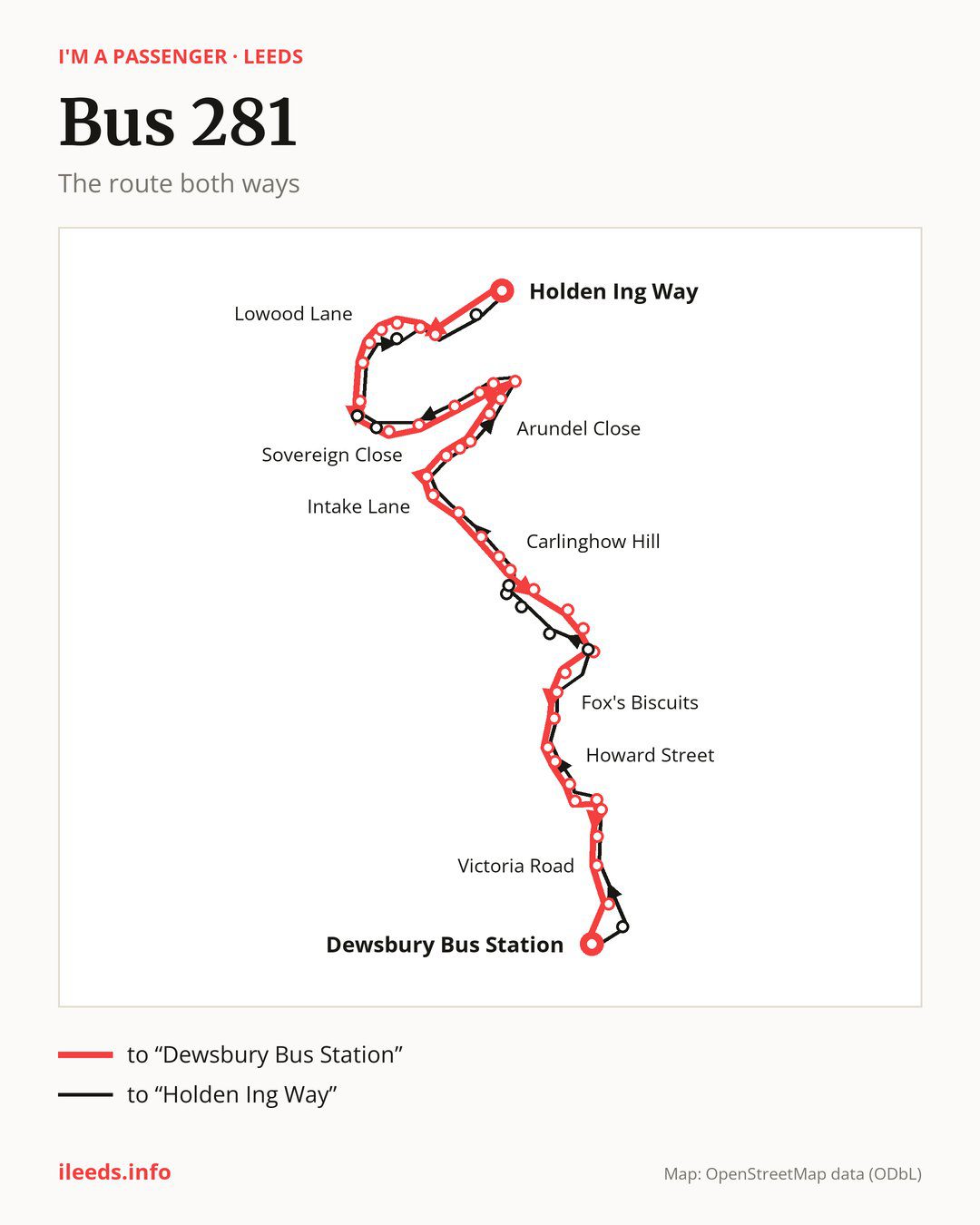
From “Holden Ing Way” to “Dewsbury Bus Station”: 43 stops. On the way: “Raikes Lane”, “Rochester Road”, “Fieldhead Academy”, “Branwell Avenue”, “Lowood Lane”, “Foxglove Road”, “Kings Drive”, “Middlegate Church Street”, “Birstall Market Place”, “Sovereign Close”. Then “Birstall Cricket Club”, “Hill Crescent”, “Clough Drive”, “Windsor Road”, “Arundel Close”, “Batley Girls High School”, “Windmill School”, “Harefield Drive”, “Woodlands Road”, “Intake Lane”. Then “Bradford Road”, “Wilton Park Gates”, “Wilton Park”, “Ruby Street”, “Carlinghow Hill”, “Victoria Mills”, “Stocks Lane”, “Batley Bus Station”, “Batley Commercial St”, “Fox’s Biscuits”. Then “Norfolk Street”, “Mount Pleasant”, “Carr Side Crescent”, “Hyrstlands Park”, “Howard Street”, “Conway Crescent”, “Town Street”, “Jack Lane”, “Mill Road”, “Victoria Road”. Before “Dewsbury Bus Station”: “Northgate”.
The return journey is different. Towards “Holden Ing Way”: 43 stops. Only in this direction does it call at, among others, “Longcauseway”, “Blakeridge Lane”, “St Mary’s School”, “Centenary Way”, “Centenary Place” and “Middlegate”. Only in the direction of “Dewsbury Bus Station” does it call at, among others, “Fieldhead Academy”, “Branwell Avenue”, “Middlegate Church Street”, “Victoria Mills”, “Stocks Lane” and “Batley Bus Station”. For the way back, board nearby: “Fieldhead Academy” → “Haworth Road” (150 m), “Branwell Avenue” → “Lowood Lane” (150 m), “Middlegate Church Street” → “Middlegate” (50 m) and “Victoria Mills” → “St Mary’s School” (200 m). Towards “Dewsbury Bus Station”, board nearby: “Longcauseway” → “Dewsbury Bus Station” (300 m), “Blakeridge Lane” → “Stocks Lane” (250 m), “St Mary’s School” → “Victoria Mills” (200 m) and “Centenary Way” → “Carlinghow Hill” (200 m).
Left column runs down, right column runs up. Filled stops are served both ways, dashed ones only one way: 10 towards “Dewsbury Bus Station” and 10 the other way. Tap a stop to see its name.
Other routes along the way
Shared sections with other routes: between “Wilton Park Gates” and “Dewsbury Bus Station” it shares the road with routes 283 and 283A; between “Birstall Market Place” and “Clough Drive” it shares the road with route 200; between “Windsor Road” and “Windmill School” it shares the road with route 213.
Connections by stop, in route order:
- Stops from “Holden Ing Way” to “Rochester Road”: bus 229
- “Middlegate Church Street” (only towards “Dewsbury Bus Station”): bus 229
- “Birstall Market Place”: bus 229
- “Sovereign Close”: bus 229
- “Ruby Street”: bus 271
- “Carlinghow Hill”: bus 271
- “Victoria Mills” (only towards “Dewsbury Bus Station”): bus 271
- “Stocks Lane” (only towards “Dewsbury Bus Station”): buses 112, 112A, 201, 212 and 271
- “Batley Bus Station” (only towards “Dewsbury Bus Station”): buses 112, 112A, 201, 212 and 271
- “Batley Commercial St”: buses 112, 112A, 201, 212 and 271
- “Fox’s Biscuits”: buses 112, 112A, 201 and 212
- “Norfolk Street”: bus 201
- “Town Street”: bus 205
- “Jack Lane” (only towards “Dewsbury Bus Station”): bus 205
- “Mill Road”: bus 205
- “Victoria Road”: buses 205, 212 and 268
- “Northgate” (only towards “Dewsbury Bus Station”): bus 268
- “Dewsbury Bus Station”: buses 202, 203, 205, 212, 250 and 268
- “Longcauseway” (only towards “Holden Ing Way”): buses 202, 203, 205, 212, 250 and 268
- “Blakeridge Lane” (only towards “Holden Ing Way”): buses 112, 112A, 201, 212 and 271
- Stops from “St Mary’s School” to “Centenary Place” (only towards “Holden Ing Way”): bus 271
- “Middlegate” (only towards “Holden Ing Way”): bus 229
- “Bankwood Way” (only towards “Holden Ing Way”): bus 229
Pages for these routes: bus 112, bus 112A, bus 200, bus 201, bus 205, bus 213, bus 229, bus 271, bus 283, bus 283A.
Passes and concessions
Tickets, passes and concessions are covered on a separate page: how to pay for public transport in Leeds.
Questions about bus 281
Does bus 281 go to “Birstall Market Place”?
Yes, in both directions.
Where can I change from bus 281 to another bus route?
Most routes stop at “Dewsbury Bus Station” (202, 203, 205, 212, 250 and 268) and “Longcauseway” (only towards “Holden Ing Way”; 202, 203, 205, 212, 250 and 268). All other stops with connections are listed above.
Checked on 27 September 2026. Source of the route and stops: West Yorkshire Combined Authority (Metro).