
Bus route 86 in Leeds links “Bramley Centre Bus Station” and “Middleton Centre”. One stop is served in one direction only. The return journey ends at “Bramley Centre” (100 m from “Bramley Centre Bus Station”).
The route of bus 86
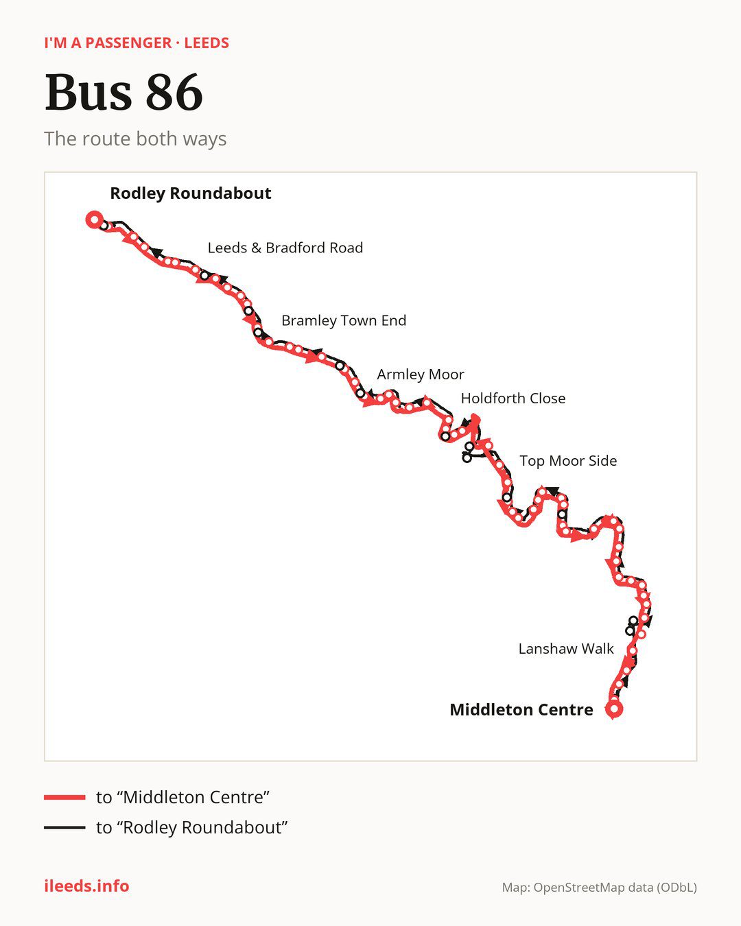
From “Bramley Centre Bus Station” to “Middleton Centre”: 48 stops. On the way: “Aston Road”, “Bramley Town End”, “Greenhill Mount”, “Cockshott Lane”, “Armley Grange Drive”, “Armley Ridge Close”, “Christ Church”, “Armley Moor”, “Pinfold Lane”, “Armley Town Street”. Then “Wesley Road”, “Brooklyn Street”, “Holy Family School”, “Holdforth Close”, “Eighth Avenue”, “Clyde Gardens”, “Clyde Approach”, “Holbeck Lane”, “Pleasant Street”, “Top Moor Side”. Then “City Evangelical Church”, “Fairfax Road”, “Beeston Hill Health Centre”, “Malvern Road”, “Lady Pit Lane”, “Northcote Green”, “Northcote Crescent”, “Hunslet Hall Road”, “Burton Road”, “Tunstall Road”. Then “City South Retail Park”, “Hunslet Green Retail Centre”, “Midland Road”, “Playfair Road”, “Moor Road”, “West Grange Drive”, “East Grange View”, “Hunslet Cemetery”, “Belle Isle Centre”, “Low Grange View”. Before “Middleton Centre”: “Windmill Road Bottom”, “Windmill Close”, “Middleton Road”, “Lanshaw Walk”, “Lanshaw View”, “Dunlin Drive”.
The return journey is different. Towards “Bramley Centre”: 51 stops. Only in this direction does it call at, among others, “Petersfield Avenue”, “Windmill Avenue”, “Dewsbury Road Hub”, “Cemetery Road Junction”, “Domestic Road” and “Wortley Lane”. Only in the direction of “Middleton Centre” does it call at, among others, “Armley Ridge Close”, “Holbeck Lane”, “City Evangelical Church”, “Hunslet Hall Road”, “Burton Road” and “Low Grange View”. For the way back, board nearby: “Armley Ridge Close” → “Armley Ridge Road” (100 m), “Holbeck Lane” → “Wortley Lane” (300 m), “City Evangelical Church” → “Cemetery Road Junction” (100 m) and “Hunslet Hall Road” → “Northcote Crescent” (100 m). Towards “Middleton Centre”, board nearby: “Petersfield Avenue” → “Windmill Close” (200 m), “Windmill Avenue” → “Windmill Road Bottom” (200 m), “Dewsbury Road Hub” → “Hunslet Hall Road” (150 m) and “Cemetery Road Junction” → “City Evangelical Church” (100 m).
Left column runs down, right column runs up. Filled stops are served both ways, dashed ones only one way: 8 towards “Middleton Centre C” and 11 the other way. Tap a stop to see its name.
Where to change
Shared sections with other routes: between “Armley Moor” and “Clyde Approach” it shares the road with routes 16 and 16A; between “Holbeck Lane” and “Beeston Hill Health Centre” it shares the road with route 65; between “Malvern Road” and “Hunslet Hall Road” it shares the road with route 24.
Connections by stop, in route order:
- “Bramley Centre Bus Station”: buses 14, 49 and 91
- “Aston Road”: buses 14, 49, 72 and 91
- “Bramley Town End”: buses 14, 72 and X11
- “Greenhill Mount”: buses 72, X6 and X11
- “Cockshott Lane”: buses 72, X6 and X11
- “Armley Grange Drive”: buses 14, 72 and X11
- “Armley Ridge Close” (only towards “Middleton Centre”): buses 14, 72 and X11
- “Christ Church”: buses 14, 15, 72 and X11
- “Armley Moor”: buses 15 and 81
- “Pinfold Lane”: buses 4, 4F, 14, 15, 72, 81, X6 and X11
- “Armley Town Street”: buses 14, 15, 72, 81, X6 and X11
- “Wesley Road”: buses 4, 4F, 14, 15, 72, 81, X6 and X11
- “Brooklyn Street”: buses 4, 4F, 15 and 81
- “Holy Family School”: buses 4, 4F, 15 and 72
- “Holdforth Close”: buses 4, 4F and 42
- “Eighth Avenue”: buses 4, 4F and 42
- “Clyde Gardens”: buses 4, 4F, 42, 229, 253, 254 and 255
- “Clyde Approach”: buses 4, 4F, 42, 229, 253, 254 and 255
- “Holbeck Lane” (only towards “Middleton Centre”): buses 229, 253, 254 and 255
- “Pleasant Street”: buses 229, 253, 254 and 255
- “Top Moor Side”: buses 51 and 52
- “City Evangelical Church” (only towards “Middleton Centre”): buses 51 and 52
- “Fairfax Road”: buses 51 and 52
- “Northcote Crescent”: buses 3A, 200, 201, 202 and 203
- “Hunslet Hall Road” (only towards “Middleton Centre”): buses 3A, 200, 201, 202 and 203
- “Burton Road” (only towards “Middleton Centre”): buses 3A, 200, 201, 202 and 203
- “Tunstall Road”: buses 3A, 200, 201, 202 and 203
- “City South Retail Park”: bus 61
- “Hunslet Green Retail Centre”: buses 13A, 47 and 61
- “Midland Road”: buses 13A, 47 and 61
- “Playfair Road”: buses 13A and 47
- “Moor Road”: buses 13A, 47 and 61
- “West Grange Drive”: buses 13A, 47 and 61
- Stops from “East Grange View” to “Belle Isle Centre”: buses 13A and 47
- “Windmill Road Bottom”: bus 13A
- “Windmill Close” (only towards “Middleton Centre”): bus 13A
- “Middleton Road”: buses 13A and 47
- “Lanshaw Walk”: buses 13A and 47
- Stops from “Lanshaw View” to “Middleton Centre”: buses 9A, 13A and 47
- “Petersfield Avenue” (only towards “Bramley Centre”): bus 13A
- “Windmill Avenue” (only towards “Bramley Centre”): buses 13A and 47
- “Dewsbury Road Hub” (only towards “Bramley Centre”): buses 3A, 200, 201, 202 and 203
- “Cemetery Road Junction” (only towards “Bramley Centre”): buses 51 and 52
- “Domestic Road” (only towards “Bramley Centre”): buses 229, 253, 254 and 255
- “Wortley Lane” (only towards “Bramley Centre”): buses 4, 4F, 42, 229, 253, 254 and 255
- “Copley Hill” (only towards “Bramley Centre”): buses 4, 4F and 42
- “Town Street Junction” (only towards “Bramley Centre”): bus 15
- “Armley Ridge Road” (only towards “Bramley Centre”): buses 14, 72 and X11
- “Eightlands Lane” (only towards “Bramley Centre”): buses 14 and 72
- “Bramley Centre”: buses 14, 49 and 91
Pages for these routes: bus X11, bus X6, bus 3A, bus 4, bus 4F, bus 9A, bus 13A, bus 14, bus 15, bus 16, bus 16A, bus 24, bus 42, bus 47, bus 49, bus 51, bus 52, bus 61, bus 65, bus 72, bus 81, bus 91, bus 200, bus 201, bus 229, bus 253, bus 255.
Passes and concessions
Which passes are available and who travels free is explained on a separate page: how to pay for public transport in Leeds.
Questions about bus 86
Does bus 86 go to “City South Retail Park”?
Yes, in both directions.
Where can I change from bus 86 to another bus route?
Most routes stop at “Pinfold Lane” and “Wesley Road” (4, 4F, 14, 15, 72, 81, X6 and X11). All other stops with connections are listed above.
Checked on 5 October 2026. Source of the route and stops: West Yorkshire Combined Authority (Metro).