
Bus route 15 in Leeds links “City Square” and “Whincover Hill”.
Which way bus 15 runs
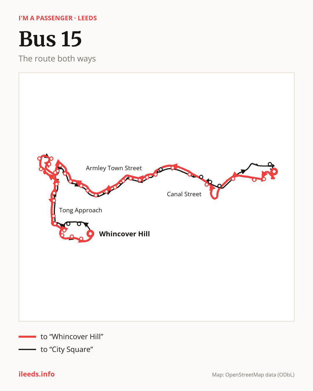
From “City Square” to “Whincover Hill”: 35 stops. On the way: “Wellington”, “Wellington Bridge”, “Canal Street”, “Armley Prison”, “Pickering Street”, “Crab Lane”, “Armley Town Street”, “Pinfold Lane”, “Armley Moor”, “Station Way”. Then “Barden Green”, “Whingate School”, “Heights Way”, “Heights Bank”, “Heights Green”, “Heights Parade”, “Heights Drive End”, “Greenthorpe Road”, “Henconner Lane”, “Gamble Hill Drive”. Then “Gamble Hill Rise”, “Gamble Hill Grange”, “Greenhill School”, “Gamble Hill”, “Butt Lane McDonalds”, “Water Lane”, “Tong Approach”, “Stonecliffe Grove”, “Chapel Lane”, “Old Farnley”. Before “Whincover Hill”: “Farnley Academy”, “Whincover Road”, “Whincover Gardens”.
The return journey is different. Towards “City Square”: 35 stops. Only in this direction does it call at, among others, “Bawn Gardens”, “Butterbowl Grove”, “Branch Road”, “Albion Way”, “Brandon Street” and “Armley Road Bottom”. Only in the direction of “Whincover Hill” does it call at, among others, “Wellington”, “Wellington Bridge”, “Canal Street”, “Crab Lane”, “Farnley Academy” and “Whincover Road”. For the way back, board nearby: “Wellington” → “City Square” (300 m), “Wellington Bridge” → “Armley Road Bottom” (350 m), “Canal Street” → “Brandon Street” (100 m) and “Crab Lane” → “Branch Road” (150 m). Towards “Whincover Hill”, board nearby: “Bawn Gardens” → “Whincover Road” (350 m), “Butterbowl Grove” → “Old Farnley” (150 m), “Branch Road” → “Crab Lane” (150 m) and “Albion Way” → “Canal Street” (200 m).
Left column runs down, right column runs up. Filled stops are served both ways, dashed ones only one way: 8 towards “Whincover Hill” and 7 the other way. Tap a stop to see its name.
Where to change
Shared sections with other routes: between “Old Farnley” and “Whincover Gardens” it shares the road with route 42; between “Wellington Bridge” and “Pickering Street” it shares the road with route 72.
Connections by stop, in route order:
- “City Square”: buses 1, 4, 4F, 7, 7A, 7S, 14, 16, 16A, 19, 19A, 23, 24, 25, 27, 28, 33, 34, 38, 39, 49, 50, 50A, 56, 60A, 64, 65, 81, 163, 200, 201, 202, 203, 229, 253, 254, 255, X6, X11 and X84
- “Wellington” (only towards “Whincover Hill”): buses 1, 4, 4F, 7, 7A, 7S, 14, 16, 16A, 19, 19A, 24, 33, 34, 49, 50, 50A, 60A, 65, 81, 163, 200, 201, 202, 203, 229, 253, 254, 255, X6 and X11
- “Wellington Bridge” (only towards “Whincover Hill”): buses 1, 4, 4F, 14, 16, 16A, 33, 34, 60A, 65, 81, 229, 253, 254, 255 and X11
- “Canal Street” (only towards “Whincover Hill”): buses 4, 4F, 16, 16A, 65, 229, 253, 254, 255 and X11
- “Armley Prison”: buses 16, 16A and 86
- “Pickering Street”: buses 14, 16, 16A, 81, 86, X6 and X11
- “Crab Lane” (only towards “Whincover Hill”): buses 14, 16, 16A, 81, 86, X6 and X11
- “Armley Town Street”: buses 14, 16, 16A, 81, 86, X6 and X11
- “Pinfold Lane”: buses 4, 4F, 14, 16, 16A, 81, 86, X6 and X11
- “Armley Moor”: buses 16, 16A, 81 and 86
- “Henconner Lane”: buses 4 and 4F
- “Gamble Hill Drive”: buses 4, 4F and 81
- “Gamble Hill Rise”: buses 4, 4F and 81
- Stops from “Gamble Hill” to “Water Lane”: buses 4, 4F and 81
- “Tong Approach”: bus 81
- “Stonecliffe Grove”: bus 81
- “Branch Road” (only towards “City Square”): buses 14, 16, 16A, 81, 86, X6 and X11
- “Brandon Street” (only towards “City Square”): buses 4, 4F, 16, 16A, 65, 229, 253, 254, 255 and X11
- “Armley Road Bottom” (only towards “City Square”): buses 4, 4F, 16, 16A, 65, 229, 253, 254, 255 and X11
- “Civic” (only towards “City Square”): buses 1, 4, 4F, 7, 7A, 7S, 14, 16, 16A, 19, 19A, 23, 24, 25, 27, 28, 33, 34, 38, 39, 49, 50, 50A, 56, 60A, 65, 81, 163, 229, 253, 254, 255, X6, X11 and X84
Pages for these routes: bus X11, bus X6, bus X84, bus 1, bus 4, bus 4F, bus 7A, bus 7S, bus 14, bus 16, bus 16A, bus 19, bus 19A, bus 23, bus 24, bus 25, bus 27, bus 28, bus 33, bus 34, bus 38, bus 39, bus 42, bus 49, bus 50, bus 50A, bus 56, bus 60A, bus 64, bus 65, bus 72, bus 81, bus 86, bus 163, bus 200, bus 201, bus 229, bus 253, bus 255.
Passes and concessions
Our page “How to pay for public transport in Leeds” describes tickets, passes and concessions, including any differences between modes of transport.
Questions and answers
Does bus 15 go to “Station Way”?
Yes, in both directions.
Where can I change from bus 15 to another bus route?
Most routes stop at “City Square” (1, 4, 4F, 7, 7A, 7S, 14, 16, 16A, 19, 19A, 23, 24, 25, 27, 28, 33, 34, 38, 39, 49, 50, 50A, 56, 60A, 64, 65, 81, 163, 200, 201, 202, 203, 229, 253, 254, 255, X6, X11 and X84) and “Civic” (only towards “City Square”; 1, 4, 4F, 7, 7A, 7S, 14, 16, 16A, 19, 19A, 23, 24, 25, 27, 28, 33, 34, 38, 39, 49, 50, 50A, 56, 60A, 65, 81, 163, 229, 253, 254, 255, X6, X11 and X84). All other stops with connections are listed above.
Checked on 5 October 2026. Source of the route and stops: West Yorkshire Combined Authority (Metro).