
Bus route 174 in Leeds links “Wakefield Bus Station” and “Garforth Town End”. One stop is served in one direction only.
Which way bus 174 runs
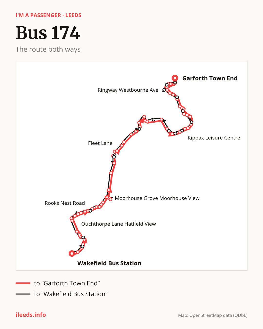
From “Wakefield Bus Station” to “Garforth Town End”: 71 stops. On the way: “Jacobs Well Lane”, “Queen Elizabeth Road”, “Pinderfields South”, “Pinderfields North”, “Bar Lane Pinderflds Hospital”, “Ouchthorpe Lane Bar Lane”, “Fieldhead Hospital”, “Ouchthorpe Lane Hatfield View”, “Ouchthorpe Lane Newton Lane”, “Rooks Nest Road Newton Lane”. Then “Rooks Nest Road Coach Road”, “Mountbatten Grove”, “Rooks Nest Road Broadmeadows”, “Rooks Nest Road Clifton Avenue”, “Rooks Nest Road Baker Lane”, “Rooks Nest Road”, “Stanley Library”, “St Peters Church”, “Lake Lock Road”, “Zion Church”. Then “Bottomboat Road”, “Moorhouse Estate”, “Moorhouse Grove Moorhouse Avenue”, “Moorhouse Grove Moorhouse View”, “Scarth Terrace Moorhouse Avenue”, “Moorhouse Avenue Moorhouse Grove”, “Newmarket Lane”, “Royds Academy”, “Oulton Drive”, “Oulton Cross Roads”. Then “Calverley Road”, “Fleet Lane”, “Woodlesford Co-op”, “Woodlesford Station”, “Bullerthorpe Lane”, “Jinny Moor Lane”, “Swillington Lane End”, “Springwell Farm”, “Whitecliffe Crescent”, “Smeaton Grove”. Then “Swillington School”, “Goody Cross Lane Whitehouse Lane”, “Whitehouse Lane Whitehouse Ave”, “Great Preston Corner”, “Gt Preston Corner”, “Gt Preston Sports Club”, “Glencoe Terrace”, “Kippax Leisure Centre”, “The Drive”, “Butt Hill”. Then “Cross Hills”, “Leeds Road Church Lane”, “Rutland Close”, “Valley Road Birch Road”, “Valley Road Valley Mount”, “Valley Ridge”, “Valley Road”, “Kippax North School”, “Emley View”, “Kippax Lane End”. Before “Garforth Town End”: “Scholars Gate”, “Garforth Academy”, “Ringway Goosefield Rise”, “Ringway Westbourne Ave”, “Westbourne Drive”, “Alandale Road Kingsway”, “Barleyhill Road Queensway”, “Barleyhill Road Lyndon Ave”, “Garforth Main St”.
The return journey is different. Towards “Wakefield Bus Station”: 74 stops. Only in this direction does it call at, among others, “Alandale Drive”, “Ringway Westbourne Grove”, “Leeds Road Selby Road”, “Valley Road Valley Ridge”, “Church Lane North” and “Gt Preston Sprt Clb”. Only in the direction of “Garforth Town End” does it call at, among others, “Bar Lane Pinderflds Hospital”, “Rooks Nest Road”, “Oulton Cross Roads”, “Calverley Road”, “Great Preston Corner” and “Gt Preston Sports Club”. For the way back, board nearby: “Bar Lane Pinderflds Hospital” → “Ouchthorpe Lane Bar Lane” (50 m), “Rooks Nest Road” → “Stanley Lane Ends” (50 m), “Oulton Cross Roads” → “Aberford Road” (100 m) and “Calverley Road” → “Fleet Lane” (150 m). Towards “Garforth Town End”, board nearby: “Alandale Drive” → “Barleyhill Road Queensway” (100 m), “Ringway Westbourne Grove” → “Ringway Westbourne Ave” (50 m), “Leeds Road Selby Road” → “Kippax Lane End” (100 m) and “Valley Road Valley Ridge” → “Valley Ridge” (50 m).
Left column runs down, right column runs up. Filled stops are served both ways, dashed ones only one way: 14 towards “Garforth Town End” and 16 the other way. Tap a stop to see its name.
Other routes along the way
Shared sections with other routes: between “Newmarket Lane” and “Swillington School” it shares the road with route 175; between “Newmarket Lane” and “Woodlesford Station” it shares the road with route 446; between “Gt Preston Corner” and “Cross Hills” it shares the road with route 163.
Connections by stop, in route order:
- “Wakefield Bus Station”: buses 100, 101, 102, 103, 104, 105, 110, 111, 118, 122, 147, 148, 149, 157, 189, 212, 268, 425 and 444
- “Jacobs Well Lane”: buses 100, 111, 147, 157 and 444
- “Queen Elizabeth Road”: buses 100, 111, 147, 157 and 444
- “Pinderfields South”: buses 103, 111, 147, 157 and 444
- “Pinderfields North”: buses 103, 111, 147, 157 and 444
- “Bar Lane Pinderflds Hospital” (only towards “Garforth Town End”): buses 103, 111, 147, 157 and 444
- “Ouchthorpe Lane Bar Lane”: buses 103 and 111
- “Fieldhead Hospital”: buses 103 and 111
- “Rooks Nest Road Newton Lane”: bus 110
- “Rooks Nest Road Clifton Avenue”: buses 101 and 444
- “Rooks Nest Road Baker Lane”: buses 101 and 444
- “Rooks Nest Road” (only towards “Garforth Town End”): buses 101 and 444
- Stops from “Stanley Library” to “Lake Lock Road”: buses 101 and 444
- “Newmarket Lane”: bus 22
- “Royds Academy”: bus 22
- “Oulton Drive”: buses 22, 140 and 141
- “Oulton Cross Roads” (only towards “Garforth Town End”): buses 22, 140 and 141
- “Calverley Road” (only towards “Garforth Town End”): buses 22, 140 and 141
- Stops from “Fleet Lane” to “Swillington School”: bus 22
- Stops from “Scholars Gate” to “Ringway Goosefield Rise”: buses 19, 19A and 164
- “Ringway Westbourne Ave” (only towards “Garforth Town End”): buses 19, 19A and 164
- Stops from “Alandale Road Kingsway” to “Garforth Town End”: buses 19, 19A and 164
- “Ringway Westbourne Grove” (only towards “Wakefield Bus Station”): buses 19, 19A and 164
- “Swillington Lane” (only towards “Wakefield Bus Station”): bus 22
- “Farrer Lane” (only towards “Wakefield Bus Station”): buses 22, 140 and 141
- “Aberford Road” (only towards “Wakefield Bus Station”): buses 22, 140 and 141
- “Stanley Lane Ends” (only towards “Wakefield Bus Station”): buses 101 and 444
- “Bar Lane” (only towards “Wakefield Bus Station”): buses 103, 111, 147, 157 and 444
- “Ivy Lane” (only towards “Wakefield Bus Station”): buses 100, 103, 111, 147, 157 and 444
Pages for these routes: bus 19, bus 19A, bus 22, bus 101, bus 110, bus 118, bus 163, bus 164, bus 175, bus 425, bus 444, bus 446.
Passes and concessions
Which passes are available and who travels free is explained on a separate page: how to pay for public transport in Leeds.
Questions and answers
Does bus 174 go to “Fieldhead Hospital”?
Yes, in both directions.
Where can I change from bus 174 to another bus route?
Most routes stop at “Wakefield Bus Station” (100, 101, 102, 103, 104, 105, 110, 111, 118, 122, 147, 148, 149, 157, 189, 212, 268, 425 and 444) and “Ivy Lane” (only towards “Wakefield Bus Station”; 100, 103, 111, 147, 157 and 444). All other stops with connections are listed above.
Checked on 4 October 2026. Source of the route and stops: West Yorkshire Combined Authority (Metro).