
Bus route 444 in Leeds runs between “Wakefield Bus Station” and “Leeds City Bus Station”. The two directions are not quite the same: 3 stops are served in one direction only, which is worth knowing before you travel.
Where bus 444 goes
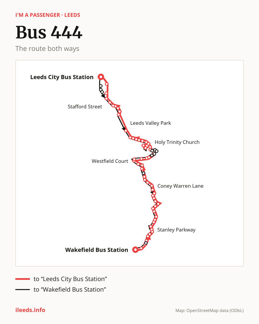
Towards “Leeds City Bus Station”: 59 stops. After “Wakefield Bus Station”, the bus calls at “Jacobs Well Lane”, “Queen Elizabeth Road”, “Pinderfields South”, “Pinderfields North”, “Novale Way”, “Aurora Drive”, “Stanley Parkway”, “Parkside Lane”, “Ferry Lane End”, “Aberford Road Allotments”. Then “Stanley Grove”, “Lime Pit Lane”, “Stanley Lane Ends”, “Stanley Library”, “Mount Road”, “Canal Lane”, “Lee Mount”, “Moor Road”, “Fenton Road”, “Moorlands Place”. Then “Coney Warren Lane”, “Beechcroft”, “Green Lane”, “Ouzlewell Green”, “Carlton Town Street”, “Carlton School”, “Westfield Road”, “Westfield Court”, “Northfield Avenue”, “Rhubarb Farm”. Then “Stainton Lane”, “Rothwell School”, “Marsh Street Library”, “Commercial Street”, “Holy Trinity Church”, “Pasture View Road”, “Cornwall Crescent”, “Manor Road Shops”, “Cotswold Drive”, “Castle Road”. Then “Knightscroft Avenue”, “Spibey Lane”, “Haigh Side Drive”, “Haigh Avenue”, “Low Shops Lane”, “St George’s Park”, “Jaw Bones”, “Leeds Valley Park”, “Queen Street”, “First Direct”. Before “Leeds City Bus Station”: “Thwaite Gate”, “Severn Road”, “Balmoral Chase”, “Church Street”, “Stafford Street”, “Donisthorpe Street”, “East Street”.
On the way back, from “Leeds City Bus Station” to “Wakefield Bus Station”: 62 stops. After “Manor Road Shops”, the bus runs a loop via “Cotswold Drive” and “Castle Road” and returns to “Manor Road Shops”. Only in this direction does it call at, among others, “Leeds Dock”, “LCC Printworks”, “Brookfield Street”, “Rothwell Ingram Pde”, “Park West” and “Rothwell War Memorial”. Only in the direction of “Leeds City Bus Station” does it call at, among others, “Marsh Street Library”, “Commercial Street”, “Pasture View Road”, “Severn Road”, “Balmoral Chase” and “Donisthorpe Street”. For the way back, board nearby: “Marsh Street Library” → “Rothwell Library” (100 m), “Commercial Street” → “Rothwell Library” (100 m), “Pasture View Road” → “Cornwall Crescent” (150 m) and “Severn Road” → “Thwaite Gate” (200 m). Towards “Leeds City Bus Station”, board nearby: “Brookfield Street” → “Donisthorpe Street” (300 m), “Rothwell Ingram Pde” → “Holy Trinity Church” (150 m), “Park West” → “Commercial Street” (200 m) and “Rothwell War Memorial” → “Commercial Street” (200 m).
Left column runs down, right column runs up. Filled stops are served both ways, dashed ones only one way: 7 towards “Leeds City Bus Station” and 10 the other way. Tap a stop to see its name.
Connections
On part of the route, between “Knightscroft Avenue” and “Leeds City Bus Station” it shares the road with route 446; between “Leeds Valley Park” and “Leeds City Bus Station” it shares the road with route 110; between “Thwaite Gate” and “Leeds City Bus Station” it shares the road with routes 140 and 141.
Connections by stop, in route order:
- “Wakefield Bus Station”: buses 100, 101, 102, 103, 104, 105, 111, 118, 122, 148, 149, 157, 174, 175, 189, 212, 268 and 425
- “Jacobs Well Lane”: buses 100, 111, 157, 174 and 175
- “Queen Elizabeth Road”: buses 100, 111, 157, 174 and 175
- Stops from “Pinderfields South” to “Novale Way”: buses 103, 111, 157, 174 and 175
- “Aurora Drive”: buses 103 and 157
- Stops from “Stanley Parkway” to “Aberford Road Allotments”: bus 103
- “Lime Pit Lane”: buses 101 and 174
- “Stanley Lane Ends”: buses 101 and 174
- Stops from “Stanley Library” to “Canal Lane”: buses 101, 174 and 175
- “Lee Mount”: buses 101 and 175
- Stops from “Westfield Court” to “Rothwell School”: bus 9A
- “Marsh Street Library” (only towards “Leeds City Bus Station”): buses 9A and 22
- “Commercial Street” (only towards “Leeds City Bus Station”): buses 9A and 22
- “Holy Trinity Church”: bus 22
- “Balmoral Chase” (only towards “Leeds City Bus Station”): buses 12, 13, 13A, 47 and 61
- “Church Street”: buses 12, 13, 13A, 47 and 61
- “Stafford Street”: buses 12, 13, 13A, 47 and 61
- “Donisthorpe Street” (only towards “Leeds City Bus Station”): buses 12, 13, 13A, 47 and 61
- “Leeds City Bus Station”: buses 1, 3A, 4, 4F, 7, 7A, 7S, 11, 12, 13, 13A, 16, 16A, 19, 19A, 23, 25, 27, 28, 33, 34, 38, 39, 40, 42, 47, 49, 50, 50A, 51, 52, 56, 60A, 64, 72, 163, 164, 165, 200, 201, 202, 203, 229, 254, 255, X6 and X84
- “Leeds Dock” (only towards “Wakefield Bus Station”): buses 12, 13, 13A and 47
- “LCC Printworks” (only towards “Wakefield Bus Station”): buses 12, 13, 13A and 47
- “Brookfield Street” (only towards “Wakefield Bus Station”): buses 12, 13, 13A, 47 and 61
- Stops from “Rothwell Ingram Pde” to “Victoria Avenue” (only towards “Wakefield Bus Station”): buses 9A and 22
- “Ivy Lane” (only towards “Wakefield Bus Station”): buses 100, 103, 111, 157, 174 and 175
Pages for these routes: bus X6, bus X84, bus 1, bus 3A, bus 4, bus 4F, bus 7A, bus 7S, bus 9A, bus 11, bus 12, bus 13, bus 13A, bus 16, bus 16A, bus 19, bus 19A, bus 22, bus 23, bus 25, bus 27, bus 28, bus 33, bus 34, bus 38, bus 39, bus 40, bus 42, bus 47, bus 49, bus 50, bus 50A, bus 51, bus 52, bus 56, bus 60A, bus 61, bus 64, bus 72, bus 101, bus 110, bus 118, bus 163, bus 164, bus 165, bus 174, bus 175, bus 200, bus 201, bus 229, bus 255, bus 425, bus 446.
Passes and concessions
Which passes are available and who travels free is explained on a separate page: how to pay for public transport in Leeds.
Questions and answers
Does bus 444 go to “Stanley Parkway”?
Yes, in both directions.
Where can I change from bus 444 to another bus route?
Most routes stop at “Wakefield Bus Station” (100, 101, 102, 103, 104, 105, 111, 118, 122, 148, 149, 157, 174, 175, 189, 212, 268 and 425) and “Leeds City Bus Station” (1, 3A, 4, 4F, 7, 7A, 7S, 11, 12, 13, 13A, 16, 16A, 19, 19A, 23, 25, 27, 28, 33, 34, 38, 39, 40, 42, 47, 49, 50, 50A, 51, 52, 56, 60A, 64, 72, 163, 164, 165, 200, 201, 202, 203, 229, 254, 255, X6 and X84). All other stops with connections are listed above.
Checked on 2 October 2026. Source of the route and stops: West Yorkshire Combined Authority (Metro).