
Bus route 11 in Leeds links “Leeds City Bus Station” and “Cross Gates Centre”.
Which way bus 11 runs
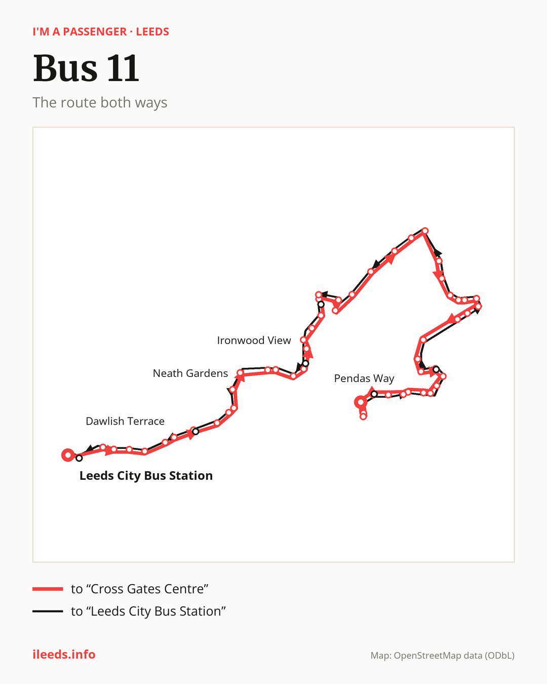
From “Leeds City Bus Station” to “Cross Gates Centre”: 51 stops. On the way: “Woodpecker Junction”, “Pontefract Lane”, “Berking Avenue”, “Raincliffe Road”, “Torre Road”, “Dawlish Terrace”, “Shaftesbury Junction”, “Gipton Approach York Road”, “South Farm Road”, “Wykebeck Valley Road”. Then “Wykebeck Valley Road Coldcotes Grove”, “Neath Gardens”, “Foundry Lane Parkway Grange”, “Foundry Lane Foundry Mill Drive”, “Foundry Lane”, “Ironwood Approach Hawkshead Crescent”, “Foundry Mill Street”, “Ironwood View”, “Brooklands Avenue Beechwood School”, “Baileys Lane Brooklands Ave”. Then “Baileys Lane Rosgill Dr”, “Bailey’s Lane”, “Eastdean Gate”, “Seacroft Bus Station”, “Seacroft Ring Road”, “Grimes Dike”, “Morwick Farm”, “Thorner Lane End”, “Scholes Lane End”, “Rakehill Road”. Then “Lynfield Gardens”, “Belle View Estate”, “St Philip’s Church”, “Crosland Mews”, “Main Street”, “Coronation Tree”, “Scholes Leeds Road”, “Scholes Village End”, “Smeaton Approach”, “John Smeaton Academy”. Before “Cross Gates Centre”: “Spur Drive”, “Rockingham Way”, “Dovedale Garth”, “Sandleas Way Top”, “Sandleas Way”, “Euston Road”, “Ethel Jackson Road”, “Pendas Way”, “Manston Park”.
The return journey is different. Towards “Leeds City Bus Station”: 50 stops. Only in this direction does it call at “Ravensworth Way”, “Baileys Lane Baileys Hill”, “Hawkshead Crescent” and “Cultural”. Only in the direction of “Cross Gates Centre” does it call at “Ironwood Approach Hawkshead Crescent”, “Ironwood View”, “Baileys Lane Rosgill Dr”, “Rockingham Way” and “Pendas Way”. For the way back, board nearby: “Ironwood Approach Hawkshead Crescent” → “Hawkshead Crescent” (100 m), “Ironwood View” → “Foundry Mill Street” (200 m), “Baileys Lane Rosgill Dr” → “Bailey’s Lane” (100 m) and “Rockingham Way” → “Ravensworth Way” (50 m). Towards “Cross Gates Centre”, board nearby: “Ravensworth Way” → “Rockingham Way” (50 m), “Baileys Lane Baileys Hill” → “Baileys Lane Rosgill Dr” (100 m), “Hawkshead Crescent” → “Ironwood Approach Hawkshead Crescent” (100 m) and “Cultural” → “Leeds City Bus Station” (200 m).
Left column runs down, right column runs up. Filled stops are served both ways, dashed ones only one way: 7 towards “Cross Gates Centre” and 6 the other way. Tap a stop to see its name.
Other routes along the way
Shared sections with other routes: between “Woodpecker Junction” and “Shaftesbury Junction” it shares the road with routes 19, 40, 56, 64, 163 and 164. On this section you can take any of them.
Connections by stop, in route order:
- “Leeds City Bus Station”: buses 1, 3A, 4, 4F, 7, 7A, 7S, 12, 13, 13A, 16, 16A, 19A, 23, 25, 27, 28, 33, 34, 38, 39, 42, 47, 49, 50, 50A, 51, 52, 60A, 72, 110, 140, 141, 165, 168, 200, 201, 202, 203, 229, 254, 255, 444, 446, X6 and X84
- “Woodpecker Junction”: buses 4, 4F, 16, 16A, 19A, 49, 50, 50A and 165
- “Pontefract Lane”: buses 4, 4F, 16, 16A, 19A, 49, 50, 50A, 61 and 165
- Stops from “Berking Avenue” to “Dawlish Terrace”: buses 19A, 61 and 165
- “Shaftesbury Junction”: buses 19A, 91 and 165
- “Gipton Approach York Road”: buses 19A, 91 and 165
- “South Farm Road”: buses 19A and 165
- “Wykebeck Valley Road”: bus 165
- Stops from “Wykebeck Valley Road Coldcotes Grove” to “Foundry Lane Foundry Mill Drive”: buses 4, 4F, 16 and 16A
- “Foundry Mill Street”: buses 4, 4F, 16 and 16A
- “Ironwood View” (only towards “Cross Gates Centre”): buses 4, 4F, 16 and 16A
- “Brooklands Avenue Beechwood School”: buses 4, 4F, 16 and 16A
- “Baileys Lane Brooklands Ave”: buses 4, 4F, 9A, 16, 16A, 22, 50 and 50A
- “Baileys Lane Rosgill Dr” (only towards “Cross Gates Centre”): buses 16, 16A, 50 and 50A
- “Bailey’s Lane”: buses 16, 16A, 50 and 50A
- “Eastdean Gate”: buses 4, 4F, 9A, 16, 16A, 22, 50 and 50A
- “Seacroft Bus Station”: buses 4, 4F, 9A, 16, 16A, 22, 50 and 50A
- “Seacroft Ring Road”: buses 16, 16A, 50 and 50A
- “Grimes Dike”: buses 16 and 16A
- “Sandleas Way”: bus 165
- “Euston Road”: bus 165
- “Ethel Jackson Road”: buses 22 and 165
- “Pendas Way” (only towards “Cross Gates Centre”): buses 22 and 165
- “Manston Park”: buses 22 and 165
- “Cross Gates Centre”: buses 9A, 22 and 165
- “Baileys Lane Baileys Hill” (only towards “Leeds City Bus Station”): buses 4, 4F, 9A, 16, 16A, 22, 50 and 50A
- “Cultural” (only towards “Leeds City Bus Station”): buses 1, 4, 4F, 16, 16A, 19A, 23, 25, 27, 28, 33, 34, 47, 49, 50, 50A, 60A, 72, 110, 140, 141, 165, 168, 200, 201, 202, 203, 229, 254, 255, 444, 446, X6 and X84
Pages for these routes: bus X6, bus X84, bus 1, bus 3A, bus 4, bus 4F, bus 7A, bus 7S, bus 9A, bus 12, bus 13, bus 13A, bus 16, bus 16A, bus 19, bus 19A, bus 22, bus 23, bus 25, bus 27, bus 28, bus 33, bus 34, bus 38, bus 39, bus 40, bus 42, bus 47, bus 49, bus 50, bus 50A, bus 51, bus 52, bus 56, bus 60A, bus 61, bus 64, bus 72, bus 91, bus 110, bus 163, bus 164, bus 165, bus 168, bus 200, bus 201, bus 229, bus 255, bus 444, bus 446.
Passes and concessions
Tickets, passes and concessions are covered on a separate page: how to pay for public transport in Leeds.
Questions and answers
Does bus 11 go to “Foundry Lane Parkway Grange”?
Yes, in both directions.
Where can I change from bus 11 to another bus route?
Most routes stop at “Leeds City Bus Station” (1, 3A, 4, 4F, 7, 7A, 7S, 12, 13, 13A, 16, 16A, 19A, 23, 25, 27, 28, 33, 34, 38, 39, 42, 47, 49, 50, 50A, 51, 52, 60A, 72, 110, 140, 141, 165, 168, 200, 201, 202, 203, 229, 254, 255, 444, 446, X6 and X84) and “Cultural” (only towards “Leeds City Bus Station”; 1, 4, 4F, 16, 16A, 19A, 23, 25, 27, 28, 33, 34, 47, 49, 50, 50A, 60A, 72, 110, 140, 141, 165, 168, 200, 201, 202, 203, 229, 254, 255, 444, 446, X6 and X84). All other stops with connections are listed above.
Checked on 25 September 2026. Source of the route and stops: West Yorkshire Combined Authority (Metro).